
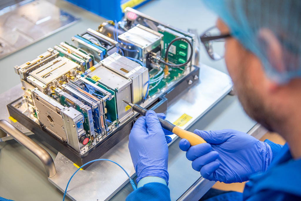
2024. On Friday night, 16 August, Hungary’s largest satellite, WREN (Water Resources in Efficient Networks), was launched on a SpaceX Falcon-9 rocket from Vandenberg Space Base in California. C3S Ltd’s latest 6U (20 cm × 10 cm × 34.05 cm) nano-satellite, a member of the Grepton Group, was built in collaboration with members of a consortium led by COMBIT Computer Technology Ltd. and the University of Óbuda and Széchenyi István University. Once in orbit, it will regularly transmit remotely sensed data from Hungary.
The EU-funded project was created in response to the rapid expansion of precision agriculture in Hungary and the increased demand for digital agrometeorological data. The mission is to provide a forecast of areas at risk of drought during periods of increasing precipitation deficit, based on continuously updated data, and thus to mitigate drought damage in Hungary through drought monitoring.
WREN (Water Resources in Efficient Networks) investigates the moisture content of the upper soil layer and the development of vegetation. The on-board multispectral imaging system will estimate the ground surface at a resolution of 16 x 16 metres over an area of nearly 10 000 square kilometres in a single pass. To monitor vegetation growth, it will collect data in visible, near-infrared and short-wave infrared wavelengths. A major advantage of the satellite is that it can not only photograph the area over which it passes, but can also look out sideways, allowing it to take denser images of a given area.
Once in orbit, the first and most important task will be to establish the link between the satellite and the ground station and then to power up the on-board subsystems. The on-board units will ensure that the satellite generates the necessary power, controls the cameras and establishes the necessary connections. The position stabilisation subsystem will bring the cameras into position. Once the cameras have been calibrated, the first images will be taken, stored by WREN and transmitted to the ground station, where they will be received by the research team for further evaluation.
Once the satellite images have been processed, the system will send high-resolution biophysical and biochemical data, which will be processed by a system using machine learning algorithms.
The mission is guaranteed by C3S Ltd.’s multiple flight history, the 100% flawless operation of its satellites launched to date, its highly reliable and long-life 6U platform and its data management service. The satellite will be operated by C3S throughout its mission.


Consortium members:
The consortium leader COMBIT Zrt. (a member of the Grepton Group) was founded in 1985 and has been operating in its current form since 2011. The main focus of its activities is the development, enhancement and operation of nationwide IT systems, with R&D activities accounting for an increasing share over the last almost 20 years. The company provides services in the following areas.
Main partners of the company. The company’s mission operations system tracks the entire mission lifecycle from launch to completion. Among nano-satellite companies, C3S has earned a prominent place by implementing large satellite solutions and technologies on a small scale that guarantee long life and high reliability. Beyond the world of CubeSats, it is present in large satellite projects as a designer of power supply and payload control systems. Its first 3U mission, RadCube, was launched in 2021. Its second mission, VIREO, also launched on a 3U platform, is entirely dedicated to industrial needs.
The University of Óbuda is supported by EKIK and AMK GEO. The University Research and Innovation Centre was established in 2014 with the aim to carry out internationally outstanding RDI activities and to bring together the RDI activities in the research laboratories of the University of ÓE, and to provide the central conditions for high-quality research. The Institute of Geoinformatics of the University of Applied Sciences is a recognised expert in research and engineering education in the fields of surveying, geoinformatics, precision farming, remote sensing, geodesy and land management.
Research related to precision farming has been conducted at the Faculty of Agriculture and Food Sciences of Széchenyi István University for decades. The 500 hectares of arable land managed by the Faculty provide sufficient farm size to carry out a wide variety of research tasks. In connection with the current project, equipment (e.g. sensor networked environmental monitoring system, low altitude multispectral remote sensing system (UAS)) is already available to support the climate monitoring programme.
Further details: www.wren.hu